Note - Will use a later post for the Google Earth link to my route
I’ve got my PPL and the privileges of having it are that I can fly as captain on a single engined aircraft and even take passengers. Despite these privileges I still feel very much in learning mode. Today I am flying from Blackbushe to Bembridge on the Isle of Wight and returning later. I was determined to wait until some good weather was on the horizon before booking an aircraft. This is because despite having some excellent flying weather over the summer period, I did not manage to fly in any of it. It was mainly due to need to book an aircraft and instructor well ahead whilst I was a PPL student. Anyway, now that is history and on Monday, I booked a Cessna 152 for today in the 9:00 to 12:00 slot. My preference was to go later and have lunch on the Isle of Wight but there was no aircraft availability at that time. On Monday, the weather forecast for the Thursday was good with sunny weather and light winds. During the next couple of days that forecast went right through a loop, passing cloudy and wet along the way. It just goes to show how hard it is to book any kind of weather related event in the UK. Anyway by Wednesday evening it was looking likely to be a nice sunny day with a slightly cooler than recent temperature and a bit of a north wind. On my planned trip there seemed to be so many new aspects to it for me that I decided to try to make a list of the things that I needed to do. The only problem is that many things actually evolve on the day, such as the actual weather, diversions requested by ATC, etc. I did my best to compile a basic list of things to do. As I did all my cross country training in the lovely Florida area with its ample sunshine, I had so far not made a landaway flight in the UK, and this would be my first. So what was I unsure about ?
Well here is part of the list :-
1 The best route to avoid too many air traffic problems.
2 The actual procedure for climbing to overhead Blackbushe to gain sufficient altitude to cross the very near Farnborough aerodrome airspace.
3 When I called Farnborough Radar, would they let me straight across their zone or would I have to divert east or west of the area. I had never flown any of these areas before so it would all look new.
4 I had never followed a radial to or from a VOR before (I had only used them to get a position fix) and how would I get on tracking a radial.
5 They had been carrying out an experiment using specific squawk codes for aircraft departing from Blackbushe, was this still in use.
6 Which aircraft would I be flying.
7 Which runway would be in use at Bembridge and would I have to use the special joining procedure if gliders were flying.
The list just goes on, so I’ll stop here before you get too bored.
At last it is Thursday morning and the skies are clear with the promised cooler northerly breeze. Yipppeeee, I am actually going flying to a nice place on a nice sunny day.
I check the weather and the winds forecasts and up-date my navigation planning log. The route I have chosen was suggested by pilots on a forum in response to a question on routes raised a year ago. The route is to climb out of Blackbushe and then request permission to cross the Farnborough ATZ and head towards the Midhust VOR. And once getting there, to turn onto a direct heading to Bembridge. This route avoids the busy Solent area and also ensures that the run across water is not too long. By crossing at 3000 ft it should ensure that you do not get wet if you suffer an engine failure.
I used the Internet to check the Notams, and also looked at a webcam on the Bembridge airfield where once again it was clear blue skies and sunshine.
Here is the webcam address
http://www.eghj.com/webcam/I was now ready to set off for the airfield. The traffic was better than I had expected and I arrived half an hour early at 8:30am. I sat around in the car for a while waiting for the offices to be opened. I could see the windsock was actively extended in a direction indicating a northerly wind and about the worst angle of crosswind you can get. A little while later I went into the offices and went through the paperwork to take charge of G-CDTX and also managed to check up on the climb overhead procedure. I booked out the aircraft and myself by phone before walking over to the 152 on the apron.
 My mount for the morning
I rang Bembridge on my mobile and determined that it was runway 30 in use and that gliders were not active today. I did the visual checks and walk-around on the aircraft that I knew needed to be topped up with fuel. I also got my PC and GPS running as a backup. Having gone through the interior checks and starting the engine, I could see a problem. The Attitude Indicator (AI) was looking really out of sorts. The display was all moving in different directions and it made you feel sick just to look at it. Hmmmm, what to do now. Well maybe it will sort itself out whilst I taxi over to the fuel pumps. Well it didn’t, so while the fuel was going in I ran over to the offices to report the problem. They said to see what happens on restart, and if there is still a problem to bring the aircraft back to the parking area. Once the tanks were full, I restarted and the AI was still no better. Oh well, taxi back then and shut down the engine again. This time one of the instructors came over and tried to fix it by moving the aircraft about but to no avail. I was given a choice, either do not go, or ignore the faulty instrument that was not needed on the planned VFR flight. It was my decision and I wanted to go. Some sticky instrument covers were fitted so that the lurching instrument was not too distracting. I stopped the engine yet again so I could strain off some of the newly filled fuel tanks to ensure there was no contamination. Eventually I was ready to go, albeit an hour behind schedule and with my head already spinning. The warm up checks went normally and I was soon taking off on runway 07 with that significant crosswind. Once airborne I started the climb whilst sticking to the circuit pattern. I soon requested to change frequency to Farnborough Radar and this was approved. After my dialogue with them I had my allocated squawk code and they asked me to fly to the west of their area. Off I went down towards Odiham and after a while they came on the radio and said that I could now make my turn onto a heading for Midhurst. At this point I realised that I had not set up my PC program to lock the centre of the map to my actual position so I had just flown off the page, and could not start fiddling with it now. So much for the backup.
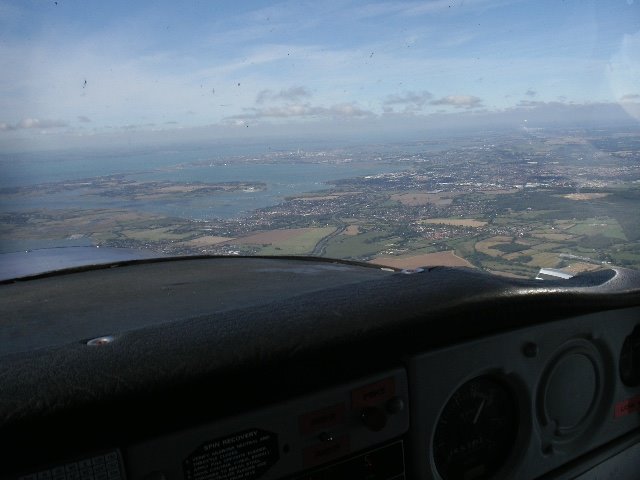
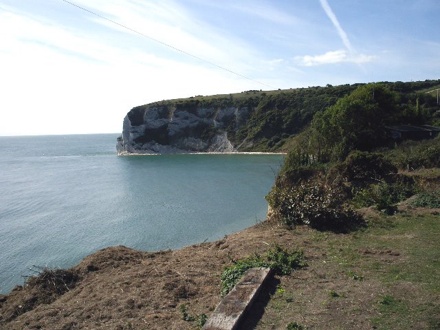
My plan had been to use the VOR instrument to guide me to Midhurst, but I was not certain of which radial I would be on after my diversion. I persisted and was heading in more or less the right direction, but found that referring to my paper chart was what remedied the situation. Once in the vicinity of the Midhust VOR beacon, I turned onto my new heading for Bembridge. At this point Farnborough Radar completed the Flight Information Service (FIS) they had been providing me. I could actually see the Solent and the Isle of Wight in the distance. I followed my planned heading and could see that it would take me over Hayling Island as expected. I climbed from 2,400ft to 3,000ft and set the radio for Bembridge Radio. The view was good, although slightly into the sun, but hey, this is the best flying weather I ever experienced in the UK.
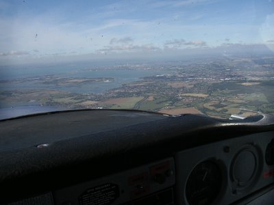 Approaching the South Coast
I can see that large tower at Portsmouth and once I am over Hayling Island there is not long to go. I called Bembridge on the radio and got the runway details and pressure settings. There was a little activity but not much. Once I was halfway across the open water, I request a straight in landing and this was granted. The runway is close to the coastline and I could see it easily. I lost the required altitude and lined up to land. Once again there was a crosswind but not too severe and I must admit that the runway did look small compared to that at Blackbushe. I wafted in over the cliffs and was soon touching down with a healthy amount of rudder to straighten her up just before we touched the runway. Bembridge Radio said “Welcome to Bembridge” and asked me to back taxi down the runway to the concrete taxiway and then to the allocated parking spot on the grass. The whole flight had taken 35 minutes in the air.
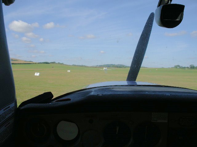
 The view from the cockpit having landed at Bembridge
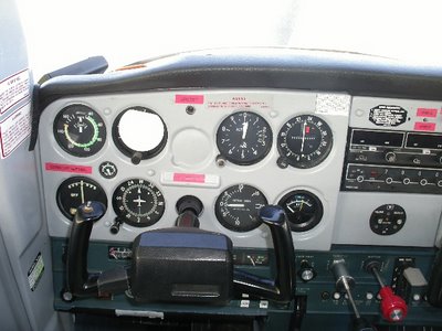 The instrument panel with the Attitude Indicator covered up
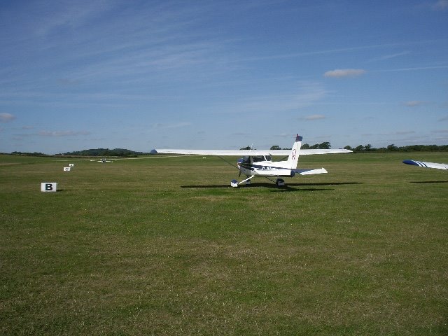
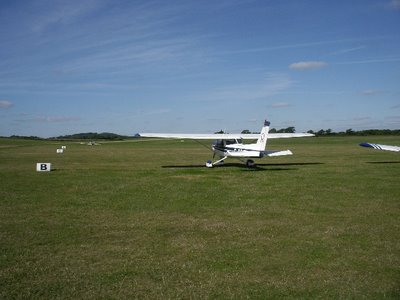 Tango Xray on the field at Bembridge
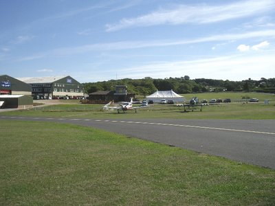 The airfield buildings
I got everything shut down and secured and walked over to the airport building to pay the very reasonable £5 landing fee. They are very friendly here. It was now getting on for 11am and on my original schedule I was supposed to be back at Blackbushe by midday. I did however want to walk on the beach at Whitecliff Bay, so I set off in that direction.
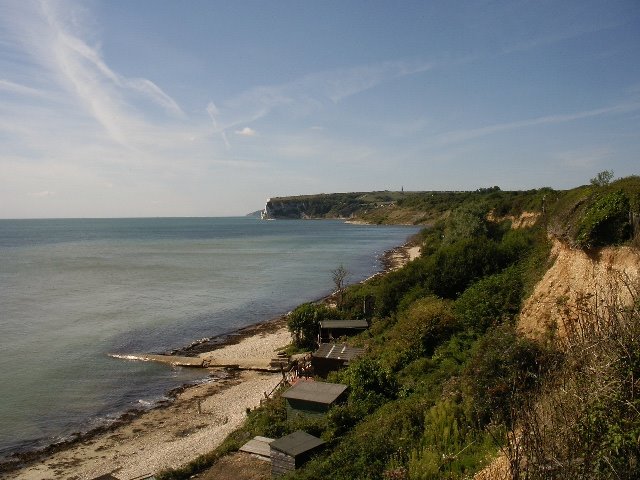
On the way I heard aircraft coming very low overhead and on looking back I could see the rather uneven runway just a shortway off. It does look as if you have to fly under the electricity cable and narrowly miss the trees on the left in order to land.
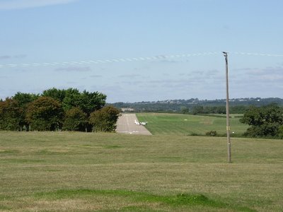 The runway looks odd from this angle
Eventually I got to the cliff edge where it was obvious that there was no easy way down to the beach. I decided to turn left and head along the cliff path to Bembridge.
 Whitecliff Bay
It was a very pleasant walk and I passed the Bembridge School that seemed very good for outdoor activities with lots of children in suitable protective gear and helmuts, using an aerial runway. In another part of the school grounds there we some children using Go-karts. It wasn’t like that when I was at school.
 Another view of the bay after I had been walking for quite a time
The cliff footpath did seem to go and on so I started thinking that I would need to get a taxi back to the airfield. At one point there was a sign saying that the path was dangerous and near the cliff edge, but in practice it seemed all very safe, with young children and older people traversing it.
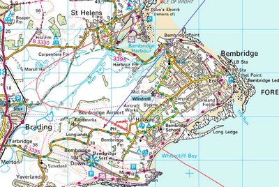 A map of the Bembridge area (it shows the track that I flew)
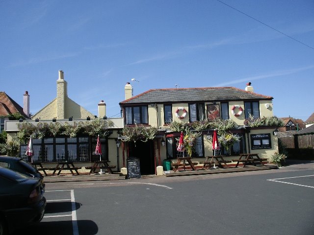
Eventually the path came to the outskirts of Bembridge and a pub called the “Crab and Lobster”.
 The Crab and Lobster at Bembridge
I was somewhat concerned about being away too long so as it was now 11:40 (and food started at 12:00) I had a glass of orange squash and some crisps. I enjoyed these at a table overlooking the Solent and the next door Coastguards Station.
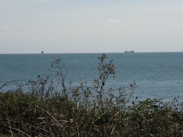
 The Coastguard Station
 Looking across the Solent
I then called for a taxi back to the airfield. After a mobile call to Blackbushe to provide a new ETA and the news that the AI was still duff, I booked out and once again returned to the aircraft. This time I got the PC setup properly after completing all the important aircraft checks. I had a bit of confusion about how one should get back to the runway, resulting in me be asked to come back after heading up the concrete taxiway. It turns out that you use a special grass taxiway which I had not spotted as there was an Islander (the aircraft) parked at the entrance to it. Once this was sorted and I had completed my warm up checks, I took off and turned to the right onto a North East heading whilst climbing as quickly as possible. I knew that now I was over the coastline and already at 1000ft, if I had an engine failure, I could always land back at Bembridge. I carried on climbing till 3000ft and levelled out. As I approached the English coastline, the views were absolutely fantastic but I did not feel that I had enough spare free capacity to find my camera and take photos. These images are just locked in my mind. As I crossed the coastline I said bye to Bembridge Radio and just admired the view. I was heading back to the Midhurst VOR and had carried out the water crossing using just my planned heading and that fact that I could see Hayling Island very clearly in front of me. I now tried to make a better job of using the VOR as a means of heading in the correct direction and did better this time. With the northerly wind, progress was slower. At one point I saw a gliders wings flash about two miles ahead and above me. I decided to take evasive action. I surprised that just moments later he was a lot closer and off to my right. You can only really see their wings when they catch in the sunlight and it did give me a bit of a scare. I was expecting to be more or less close to the Midhurst VOR at 13:00 and I was in the right place. I turned onto my new heading and called Farnborough Radar. They gave me height instructions and in effect let me fly directly over the western end of their airfield. So I was soon approaching the M3 and got permission to change to Blackbushe Information. Landing was on runway 07 and there was still the crosswind. I crossed the field and descended on the deadside to the circuit height of 800ft and after turning downwind, was soon back on the ground at 13:15. The flying time on the return leg had been 42 minutes.
I taxied to the parking area and got everything shutdown. The AI had not improved but a replacement had been organised. I completed all the paperwork.
I had thoroughly enjoyed my flight on a beautiful sunny day. The trick will be to reduce the brain workload or at least move some of the new challenges to the back of my brains a bit, as I get used to them.
Hope this has not been too boring but it is the sort of thing I would have liked to have read. Sad really, but I am enjoying myself.
Just in case this flying stuff does not keep me too busy, I have just enrolled for water colour painting, and guitar playing classes. I think that getting music out of a guitar could be my biggest ever challenge.
Regards
Peewit